Original Oil Painting by A. Vonn Hartung.
(Scroll down for Spanish text)
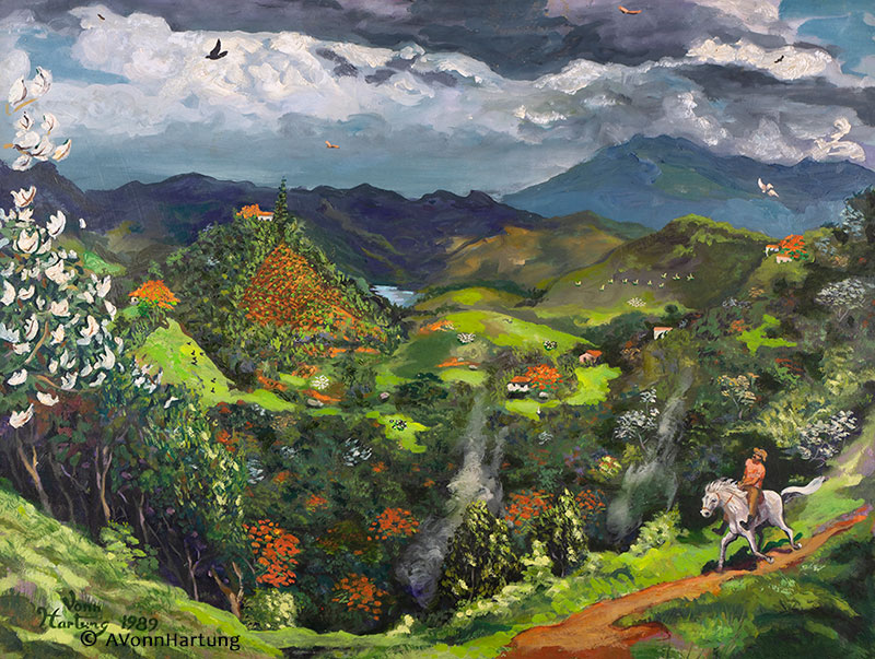
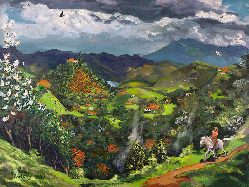
“Peace in the Valley” is a mountaintop view of Puerto Rico, looking North towards the Atlantic Ocean; a section of San Juan is visible in the distance at the upper left, and a cement quarry to the right. Snuggled in the middle is a valley farm with its silos and farmhouse in one of the various pastures protected by the surrounding hills.
Two small villages populate this pastoral scene. The beautiful fiery reds of Flamboyans and the passionate purples of the Reina de las Flores trees complete a typical landscape just a short distance inland from the sparkling beaches of Puerto Rico.
Lying about 75 miles north of Puerto Rico in the Atlantic Ocean at the boundary between the Caribbean and North American plates is the Puerto Rico Trench, the largest and deepest trench in the Atlantic.
The story behind the painting
This is an oil painting (14 x 22 inches) I did from my neighbor’s balcony, two houses from ours, looking down into the valley. You can see the Atlantic Ocean in the far distance. The farm that you see in the center is named Finca Elena, meaning Elena’s Farm, and it has now been developed into half-million-dollar homes. The pyramid-like excavation visible to the upper right is an ongoing quarry where they pulverize the rock to produce cement.
At the time I painted the picture, we were struggling against a waste management company called BFI (Browning-Ferris Industries), which wanted to convert the farm into a regional landfill.
Patty and I had just started building our house, and we only had the floor laid down, with no walls yet; the first painting I did in it was on the floor.
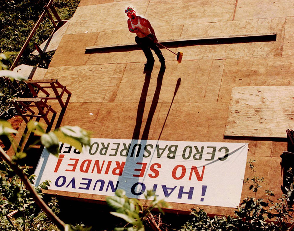
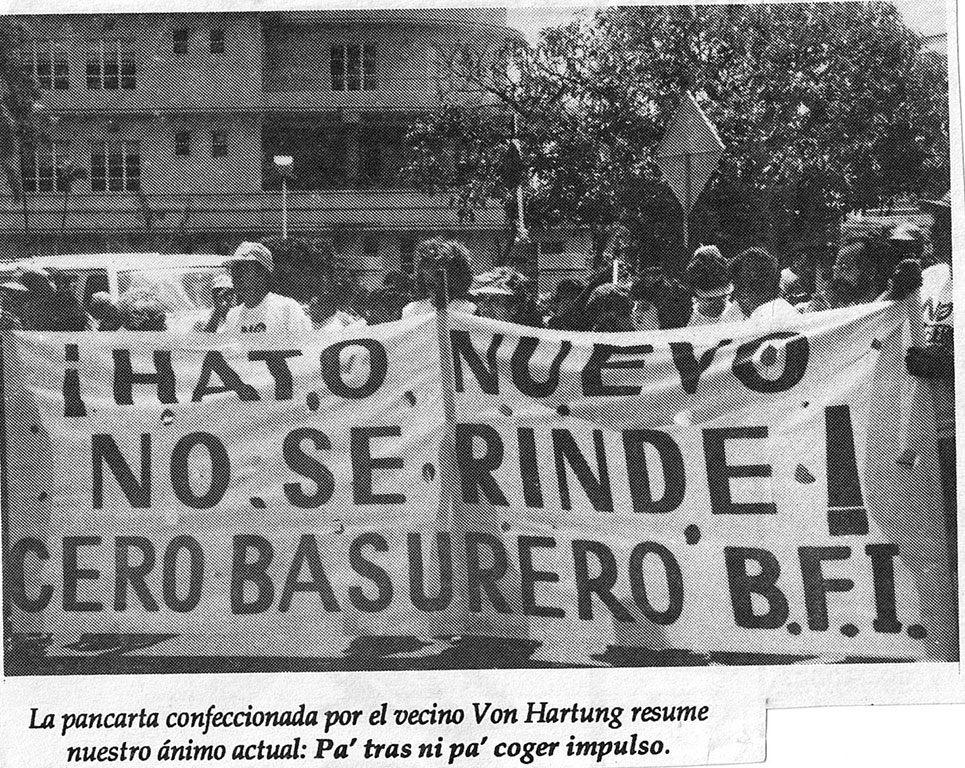
I printed a huge banner, “No se Rinde! Cero Basurero BFI (Don’t Give up! Zero dump BFI) for the fight against BFI. This is how we met all our neighbors, in a struggle that lasted over 1 ½ years.
BFI tried to make us look minor and incompetent, brought in scientists from other parts of the world, France, the UK, and one guy even wore a turban. Our defense was a logical one, given the presence of seven natural springs in the valley, which is the origin of the Guaynabo River. Their defense was that they proposed lining the entire valley with rubber.
We finally prevailed, and now it is filling up with half-million-dollar homes.
This was the theme song of our struggle against BFI. It was blasted from loudspeakers mounted on the lead car during every protest event.
“La Muralla” by Haciendo Punto En Otro Son
Buy a giclee print of this painting
******************************
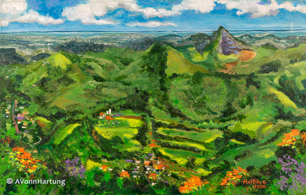
Peace in the Valley es una vista de la cima de una montaña de Puerto Rico, mirando al norte hacia el Océano Atlántico; una sección de San Juan es visible en la distancia en la parte superior izquierda y una cantera de cemento a la derecha. Acurrucada en el medio hay una granja en el valle con sus silos y una casa de campo en uno de los varios pastos protegidos por las colinas circundantes.
Dos pequeños pueblos pueblan esta escena pastoral. Los hermosos rojos ardientes de los Flamboyanes y los apasionados púrpuras de los árboles Reina de las Flores completan un paisaje típico a poca distancia tierra adentro de las resplandecientes playas de Puerto Rico.
La topografía de Puerto Rico se caracteriza por tres regiones principales: una cordillera montañosa central (la Cordillera Central), amplias llanuras costeras y una singular región kárstica en el norte, con impresionantes formaciones de piedra caliza. La isla es principalmente montañosa, siendo el Cerro de Punta el pico más alto. Presenta diversos paisajes, incluidos una fosa al norte, playas de arena, manglares e islas más pequeñas en alta mar.
Puerto Rico se encuentra en la zona de contacto entre la placa del Caribe y la placa norteamericana. Esto significa que actualmente está siendo deformada por las tensiones tectónicas provocadas por la interacción de estas placas.
Estas tensiones pueden provocar terremotos y tsunamis. Estos eventos sísmicos, junto con los deslizamientos de tierra, representan algunos de los riesgos geológicos más peligrosos en la isla y en el noreste del Caribe.
Ubicada a unas 75 millas al norte de Puerto Rico en el océano Atlántico, en el límite entre las placas del Caribe y América del Norte, se encuentra la Fosa de Puerto Rico, la fosa más grande y profunda del Atlántico.
La fosa tiene 1.090 millas de largo y aproximadamente 60 millas de ancho. En su punto más profundo, conocido como la profundidad de Milwaukee, tiene una profundidad de 27.493 pies, o aproximadamente 5,21 millas.
La historia detrás de la pintura
Esta es una pintura al óleo (14 x 22 pulgadas) que pinté desde el balcón de mi vecino, a dos casas de la nuestra, con vistas al valle. Se puede ver el océano Atlántico a lo lejos. La finca que se ve en el centro se llama Finca Elena, y ahora se ha convertido en casas de medio millón de dólares. La excavación en forma de pirámide, visible arriba a la derecha, es una cantera en funcionamiento donde pulverizan la roca para producir cemento.
En el momento en que pinté el cuadro, estábamos luchando contra una empresa de gestión de residuos llamada BFI (Browning-Ferris Industries), que quería convertir la granja en un vertedero regional.
Patty y yo acabábamos de empezar a construir nuestra casa, y solo teníamos el suelo, sin paredes; El primer cuadro que hice allí fue en el suelo.
Imprimí una pancarta enorme: “¡No se rinde! Cero Basurero BFI, para la lucha contra el BFI. Así conocimos a todos nuestros vecinos, en una lucha que duró más de un año y medio.
El BFI intentó hacernos quedar como insignificantes e incompetentes, trajo científicos de otras partes del mundo, Francia, el Reino Unido, y un hombre incluso llevaba turbante. Nuestra defensa era lógica, ya que había siete manantiales naturales en el valle, y este valle es el origen del río Guaynabo. Su defensa fue que proponían revestir todo el valle con caucho.
Finalmente prevalecimos, y ahora se está llenando de casas de medio millón de dólares.
Esta fue la canción principal de nuestra lucha contra el BFI. Se escuchaba a todo volumen desde los altavoces del carro de adelante durante cada acto de protesta.
“La Muralla” de Haciendo Punto En Otro Son
https://youtu.be/H68kVhSLbE4?si=FZHBXu9hRG6DNySz